
If you’ve live in California for any length of time, then you are well-acquainted with the natural disaster our state is known for — an earthquake. I’ve lived here my whole life and am vividly familiar the “bigs ones” that have rocked our state in the last 40 years.
Fortunately, none ever harmed anything vital in my life. Not even my psyche for very long. It’s amazing, after 60 plus years, how inured I’ve become to this quintessential Golden State calamity. In fact, I’ve lived much of my life in close proximity to the San Andreas fault and guess I’ve just gotten used to being surprised by tremors.
Although I rarely think about this longest and most active fault in the United States, it is, relatively speaking, right in my back yard. It, as well as a number of branches, traverses both Monterey County and San Benito County, right through the towns of Parkfield, Hollister and San Juan Bautista. Both Parkfield and Hollister claim the moniker “Earthquake Capital of the World.” It’s an apt claim.
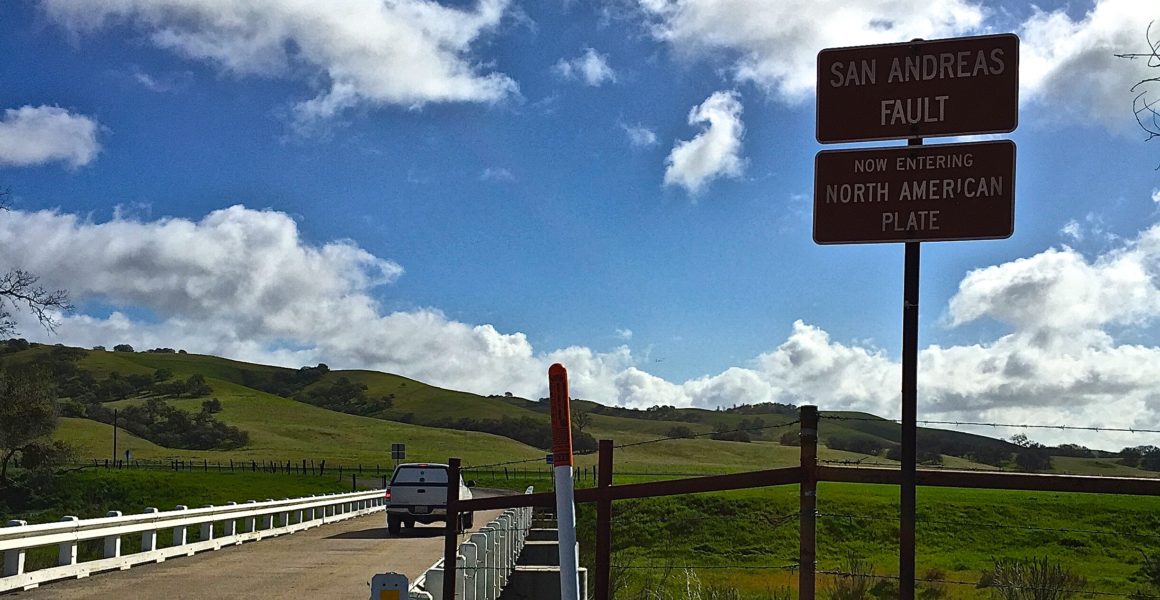
Scientists spend a lot of time in Parkfield. In fact, they pay more attention to earthquake activity in this area than any other place in the world. There’s a bridge across a dry creek bed that makes it possible to drive right over the fault. So one Sunday afternoon, my guy and I did just that … drove across the meeting of two tectonic plates, the Pacific and North American. The earth didn’t move, but it was still a pretty cool moment. After lunch at the Parkfield Cafe, we drove up Highway 25 to Hollister, the other “Capital.”
Hollister’s claim to quake fame has to do with aseismic creep … or fault creep … along the Calaveras fault, a branch off the San Andreas. The Calaveras bisects the city north to south — right through the middle of town. Aseismic means there’s a lot of shifting and movement in-and-around the city that doesn’t have much to do with earthquake activity. The result is a bunch of cockeyed houses, curbs, sidewalks and roads, matched by an equal bunch of geologists, not at all cockeyed, fascinated by this slow-motion shifting. It’s ever-so-leisurely splitting the town in half. Of course, that won’t happen in my lifetime, or my children’s, or their children’s or theirs … and so on and so on until, well, centuries from now.
There’s a walking tour, you can download a map, that takes you past all of the creepy anomalies. We did it, without tripping or invading anyone’s privacy!
Through no fault of our own, we were having such a shocking good time we decided to end our Sunday excursion at San Juan Bautista and our final exploration of the San Andreas. It’s accessed near Old Mission San Juan Bautista which, unfortunately, was built directly atop the fault line. We found it below the cemetery on the east side of the Church. Not surprisingly, the Mission suffered damage from numerous quakes, even the 1906 7.9 magnitude one that decimated San Francisco. No quaking in our boots on that day, though, it was quiet and tranquil.
But you can bet that below the surface those tectonic plates are revving up for a big one. So, remember if it happens — drop, cover and hold on!
